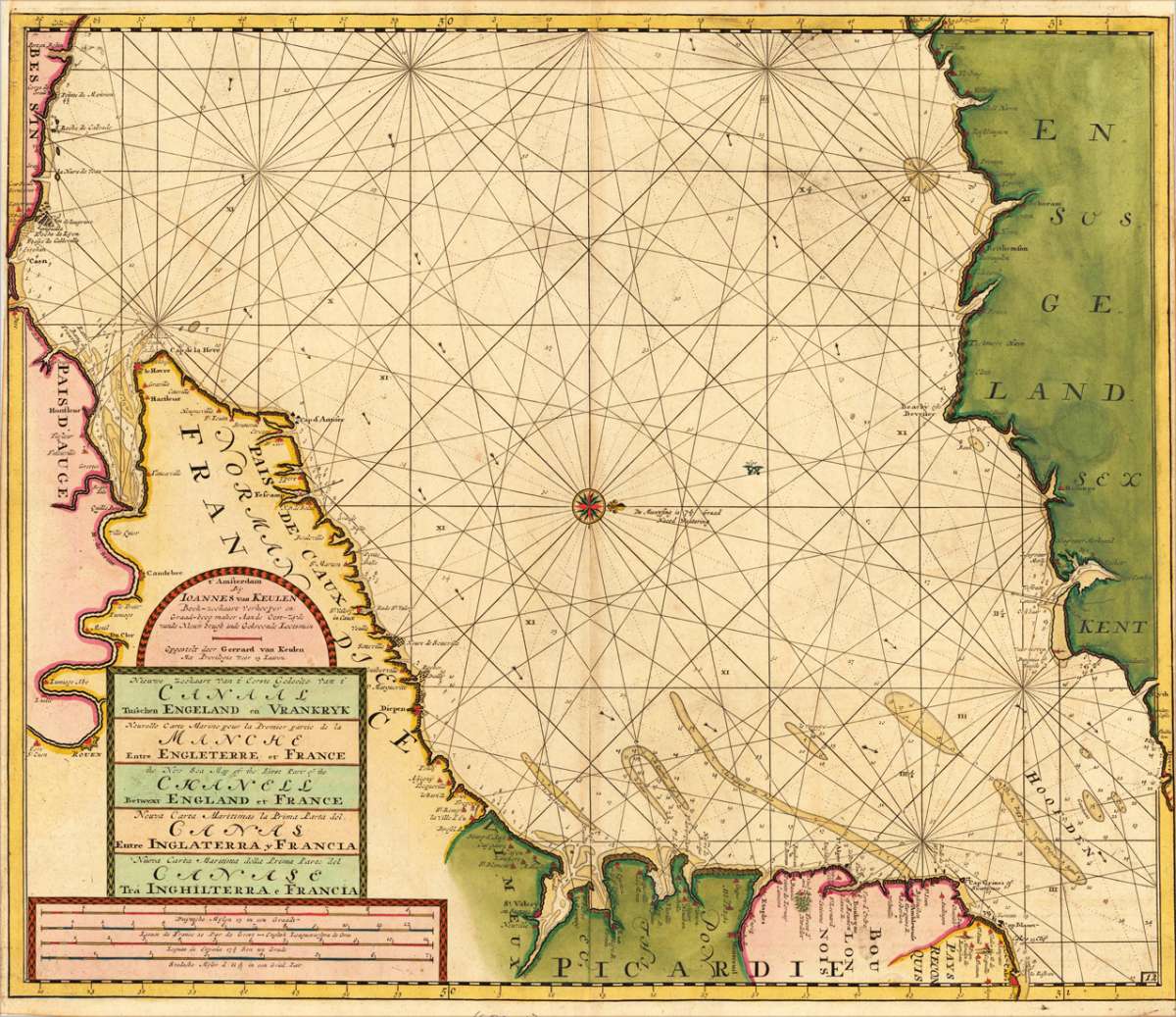
van Keulen, Joan.
Nieuwe Zeekaart Van t' Eerste Gedeelt Van t' Canaal Tufschen Engeland en Vrankryk ... The New Sea map of...
Eigenschaften
- Published: C. Vogt , Amsterdam
- Published date: 1684
- Type: Antique Map, map
- Technique: Copper engraving / later handcolor
- Issue date: (1684).
- Category: The English Channel
- Size: 523 by 617mm (20 by 24 inches).
- Stock number: 17465
- Condition: In very good condition. A few old mendings in the paper. 523 by 617mm (20 by 24 inches).
Article description
Article description
Original antique copper engraving, uncolored as published. Decorative hand colored seachart showing the English channel between Sussex and Kent and the Picardie in France. The English and French coastlines providing a lot of information on cities and smaller placenames along the coasts. As well anchorplaces, depths and sandbanks are shown. Ornated in the lower left corner with a title cartouche and milage scale in four languages. Johannes van Keulen (1654 in Deventer – 1715 in Amsterdam) was a 17th-century Dutch cartographer. He published the influential nautical atlas the Zee-Atlas and the pilot guide Zee-Fakkel (meaning Sea-Torch in English). In 1678 Johannes van Keulen established himself in Amsterdam and in 1680 he obtained a patent from the States of Holland and West Friesland allowing him to print and publish maritime atlases and shipping guides. These were books of maps and descriptions of itineraries, used by helmsmen for safe navigation. The patent was a kind of protection against illegal copying of produced books and charts. This was especially important for the atlases which were made with extensive initial costs. Van Keulen named his firm 'In de Gekroonde Lootsman' ('In the Crowned Pilot'). Soon Van Keulen struck a deal with cartographer Claes Jansz. Vooght. From 1681 onwards the Nieuwe Lichtende Zee-Fakkel appeared, a five-volume atlas for which Vooght compiled the maps[1] and which was illustrated by Jan Luyken. The five volume Zee-Fakkel made Johannes van Keulen famous. The Zee-Fakkel was published in 5 volumes between 1681 and 1684 containing over 130 new charts. (Wikipedia)You might also be interested in the following products

 De Custen van...
 Fascinating detailed seachart of the south-eastern coast of England showing the coastline from Lizard Point over...
€950.00
 Neueste Karte von...
 Steelengraving, handcolored in outline when published. The detailled map of the British Isles is providing a lot of...
€80.00
 Anglia Cambdeni,...
 Original antique copper engraving, hand colored in outline and wash when published. Decorative detailled map...
€195.00
Recently viewed products