Weigel, Christoph
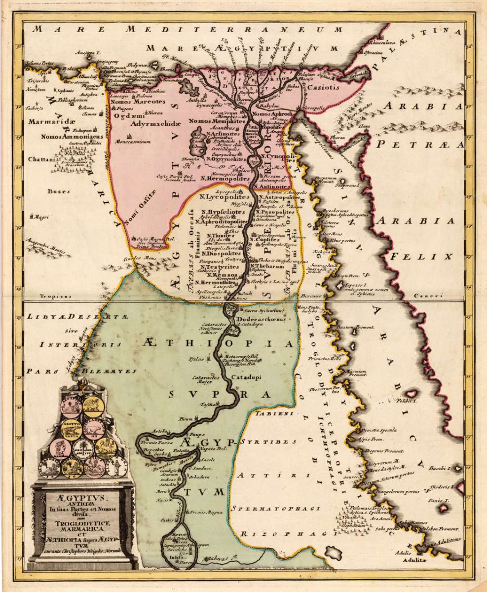
Aegyptus, antiqua in fuas Partes et Nomos divila, cum troglodytice, marmarica et Aethiopia fupra Aegyptum - curante...
€195.00
Prices incl. VAT plus shipping costs
This item is sold. Please contact us if you are searching for this item.
Eigenschaften
- Published: Chr. Weigel. , Nürnberg
- Published date: 1719
- Technique: Copper engraving / Original color.
- Type: Antique Map, map
- Issue date: 1719
- Category: Egypt & the Red Sea
- Size: 399 by 326mm (15 by 12 inches).
- Stock number: 18363
- Condition: In very good condition, a minor hardly visable crease in the lower part of the map. 399 by 326mm (15 by 12 inches).
Article description
Article description
Original antique copper engraving, hand colored in outline and wash when published. The map shows the 'antique Egypt' and the neighbouring Red Sea, as well detailled the river Nile with the Niledelta. Many antique place names are found on the map, as well some mountains, lakes and oasis. In the lower left corner a decorative title cartouche ornated with antique coins with symbols to the 'antique Egypt'. Johann Christoph Weigel, known as Christoph Weigel the Elder (9 November 1654 – 5 February 1725), was a German engraver, art dealer and publisher. He was born at Redwitz, Free imperial city of Eger in Egerland, and died in Nuremberg, aged 70. The cartographer Weigel worked around 1719 in Nürnberg and his maps are showing the typical style of this period in map making in Southern German. He worked very close as with Johann B. Homann in Nürnberg. All his maps were hand colored in outline and decorative body color immediatelly in his printing house, after they were printed.You might also be interested in the following products
 Aegypti Tabula
 Original copper engraving, uncolored. Published in Pierre Du Val's atlas ,Anderer Theil der allgemeinen...
€90.00
 Etats du Roi de...
 Original antique copper engraving, uncolored as published. Two interesting maps of North Africa on 1 double page...
€80.00
 Neueste Karte von...
 Steel engraving, in original colors, as published. A detailed map of Tunisia with many place names inland and along...
€80.00
 Neueste Karte von...
 Steel engraving, in original colors, as published. A detailed map of Nubia and Habesch with the Red Sea.
€60.00
Recently viewed products