Weigel, Christoph
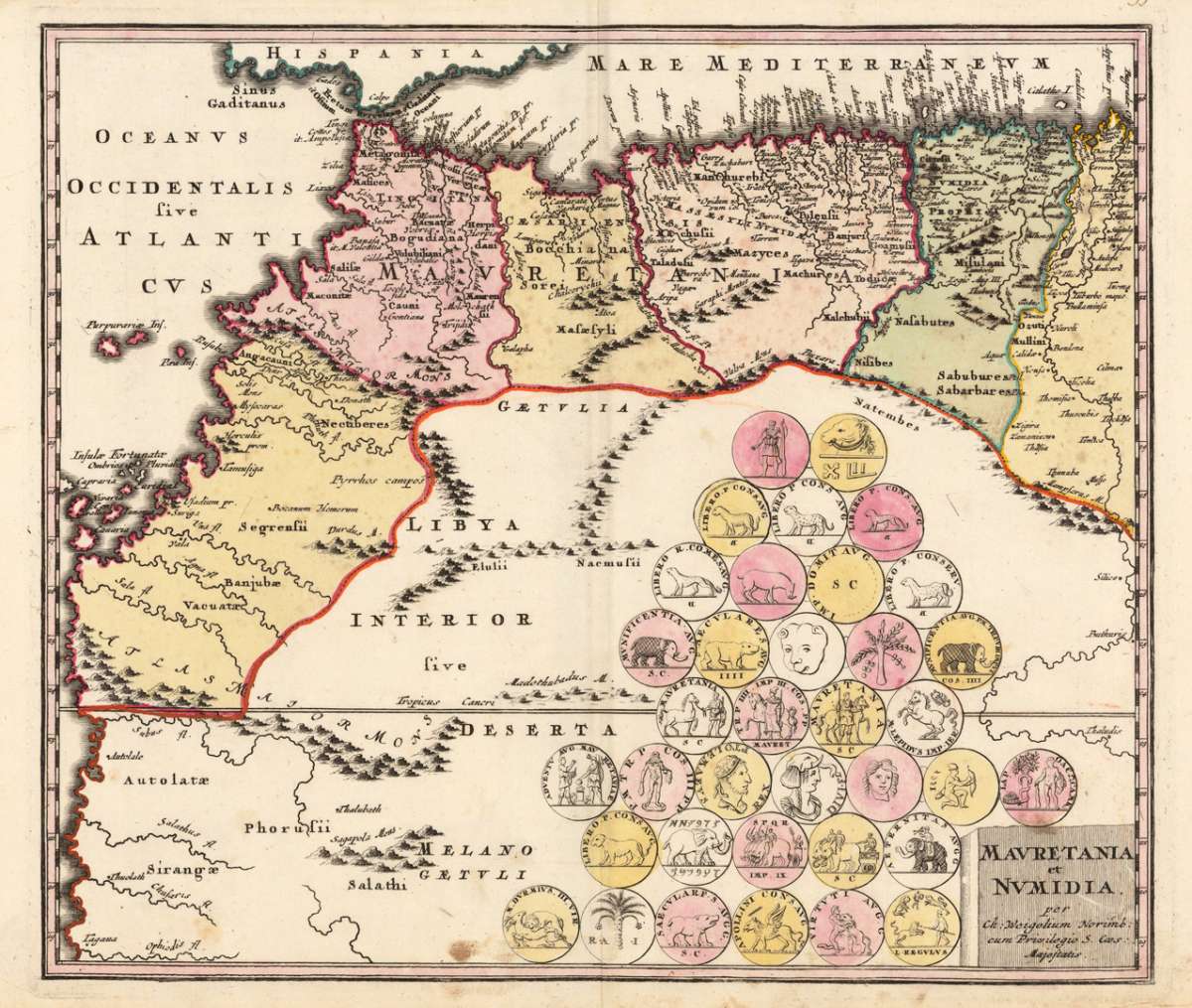
Mavretania et Numidia. - Per Ch: Weigelium Norimb: cum Privilegio S. Caes: Majestatis.
Eigenschaften
- Published: C. Weigel , Nürnberg
- Published date: 1719
- Technique: Copper engraving / Original color.
- Type: Antique Map, map
- Issue date: 1719
- Category: Marocco & North Africa
- Size: 326 by 378mm (12 by 15 inches).
- Stock number: 18834
- Condition: In excellent condition. 326 by 378mm (12 by 15 inches).
Article description
Article description
Original antique copper engraving, hand colored in outline and wash when published. Decorative map of Mauritania and Numidia showing North Africa, Marocco and the adjacenting islands in the Atlantic Ocean. With many engraved place names, mountains and rivers. Ornated with engrave antique coins of these antique regions. Johann Christoph Weigel, known as Christoph Weigel the Elder (9 November 1654 – 5 February 1725), was a German engraver, art dealer and publisher. He was born at Redwitz, Free imperial city of Eger in Egerland, and died in Nuremberg, aged 70. The cartographer Weigel worked around 1719 in Nürnberg and his maps are showing the typical style of this period in map making in Southern German. He worked very close as with Johann B. Homann in Nürnberg. All his maps were hand colored in outline and decorative body color immediatelly in his printing house, after they were printed.You might also be interested in the following products
 Aegypti Tabula
 Original copper engraving, uncolored. Published in Pierre Du Val's atlas ,Anderer Theil der allgemeinen...
€90.00
 Etats du Roi de...
 Original antique copper engraving, uncolored as published. Two interesting maps of North Africa on 1 double page...
€80.00
 Neueste Karte von...
 Steel engraving, in original colors, as published. A detailed map of Tunisia with many place names inland and along...
€80.00
 Neueste Karte von...
 Steel engraving, in original colors, as published. A detailed map of Nubia and Habesch with the Red Sea.
€60.00
Recently viewed products