Homann, Johann Baptist
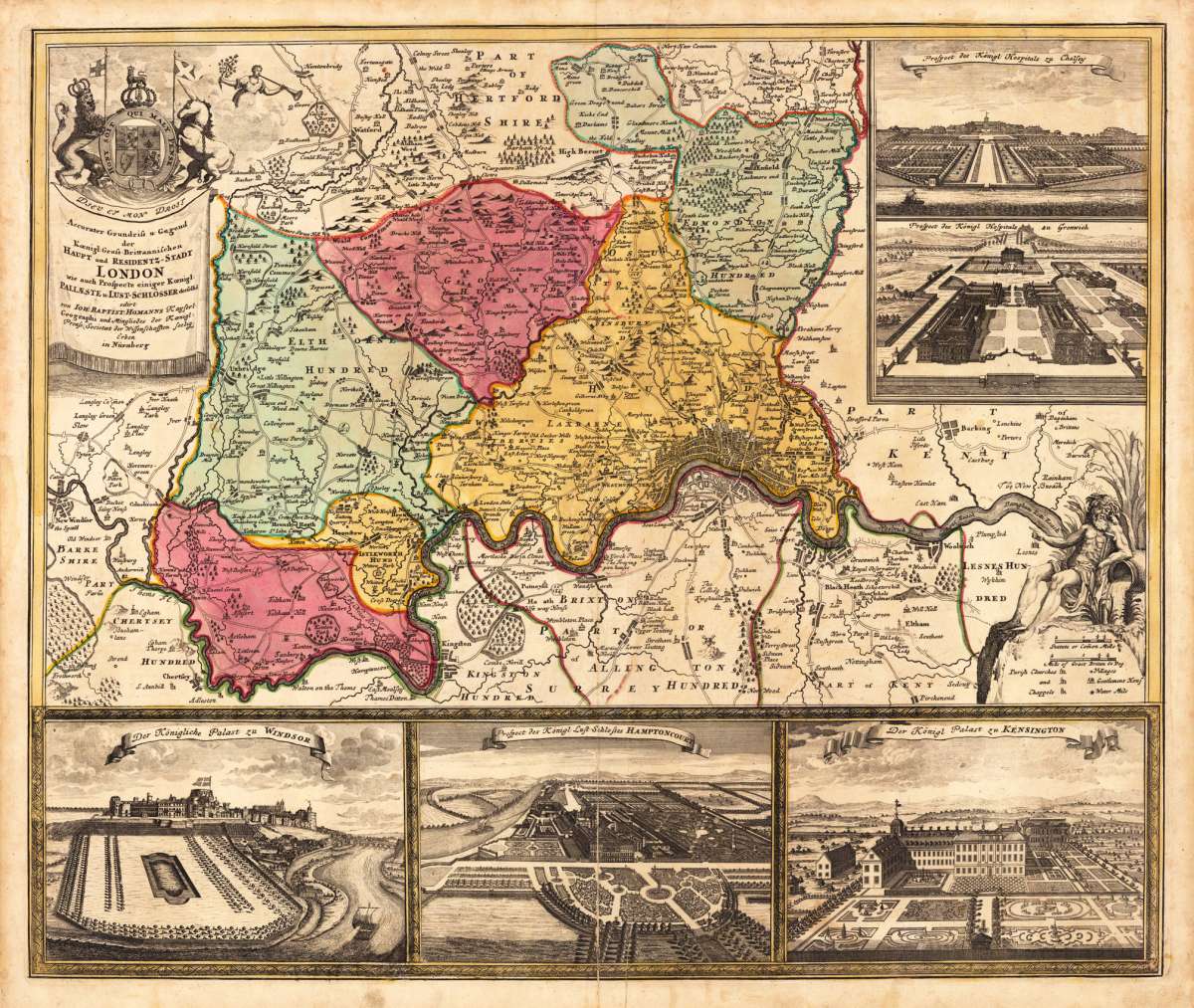
Accurater Grundriss u: Gegend der Koenigl: Gross-Brittannischen Haupt und Residentz-Stadt London wie auch Prospecte...
Eigenschaften
- Published: Homann , Nürnberg
- Published date: 1720
- Technique: Copper engraving / Original color.
- Type: Antique Map, map
- Issue date: 1720-30.
- Category: London
- Size: 495 by 590mm (19 by 23 inches).
- Stock number: 19185
- Condition: A strong impression in very good condition. At the lower centre fold an old mended split. 495 by 590mm (19 by 23 inches).
Article description
Article description
Original antique copper engraving in full contemporary handcolor in wash and outline when published. A fine antique map, which shows London and its near by surrounding. The map is equipped with four insets showing the Royal Hospital in Chelsea and Greenwich, the Royal Palace of Windsor, the view of the Royal Castle of Hampton court and the Royal Palace of Kensington. These little views are nicely engraved with streets, parks, trees and buildings. Johann Baptist Homann (20 March 1664 – 1 July 1724) was a German geographer and cartographer, who also made maps of the Americas. Homann was born in Oberkammlach near Kammlach in the Electorate of Bavaria. Although educated at a Jesuit school, and preparing for an ecclesiastical career, he eventually converted to Protestantism and from 1687 worked as a civil law notary in Nuremberg. He soon turned to engraving and cartography; in 1702 he founded his own publishing house. Homann acquired renown as a leading German cartographer, and in 1715 was appointed Imperial Geographer by Emperor Charles VI. Giving such privileges to individuals was an added right that the Holy Roman Emperor enjoyed. In the same year he was also named a member of the Prussian Academy of Sciences in Berlin. Of particular significance to cartography were the imperial printing privileges (Latin: privilegia impressoria). These protected for a time the authors in all scientific fields such as printers, copper engravers, map makers and publishers. They were also very important as a recommendation for potential customers. In 1716 Homann published his masterpiece Grosser Atlas ueber die ganze Welt (Grand Atlas of all the World). Numerous maps were drawn up in cooperation with the engraver Christoph Weigel the Elder, who also published Siebmachers Wappenbuch. Homann died in Nuremberg in 1724. He was succeeded by his son Johann Christoph (1703-1730). The company carried on upon his death as Homann heirs company, managed by Johann Michael Franz and Johann Georg Ebersberger. After subsequent changes in management the company folded in 1852.[1] The company was known as "Homann Erben", "Homanniani Heredes", or "Heritiers de Homann" abroad. (Wikipedia)You might also be interested in the following products
 Moluccae Insulae...
 Original antique copper engraving, hand colored in outline and wash when published. A highly decorative map of the...
€550.00
 Pascaert van...
 Original antique copper engraving, uncolored as published. Detailed chart of the Northeastern part of Canada,...
€1,750.00
 Pascaarte vande...
 Copper Engraving, uncolored by van Keulen, Joan, published 1684-1704 by Johannes van Keulen, Amsterdam. Image size:...
€1,100.00
 Guiana sive...
 Copper engraving, hand colored in outline and wash when published. French text edition. Decorative map extending...
€325.00
Recently viewed products