Blaeu, Guijelmus & Joan.
Tabula Castelli ad Sandflitam, qua Simul inundati agri, alluviones, Foßae, alvei, quae Bergas ad Zomam et Antverpiam...
€275.00
Prices incl. VAT plus shipping costs
This item is sold. Please contact us if you are searching for this item.
Eigenschaften
- Published: J. Blaeu. , Amsterdam
- Published date: 1643
- Technique: Copper engraving / Original color.
- Type: Antique Map, map
- Issue date: 1643-50
- Category: Berghen Op Zoom, Santvliet & Antwerp
- Size: 384 by 500mm (15 by 19 inches).
- Stock number: 19629
- Condition: In very good to excellent condition. A minor old mended split (nearly not visibly) in the blank margin of at the lower strengthened centre fold. 384 by 500mm (15 by 19 inches).
Article description
Article description
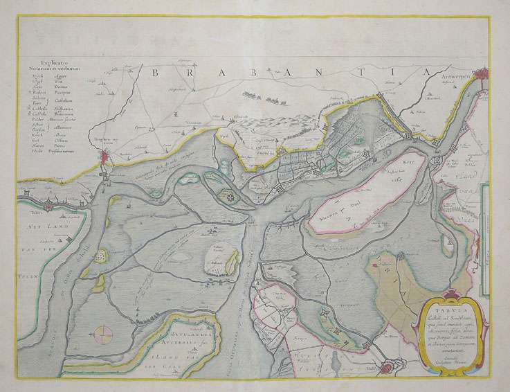
Original antique copper engraving, hand colored in outline published in Joan Blaeu's 'Atlas Novus'. This antique map shows the area between 'Bergen Op Zoom', Santvliet (Zandfliet) and Antwerp in the Netherlands. In the upper left corner we see the explanation for the map and in the lower right corner we have the title cartouche. The map is very detailed, its shows the river Schelde with its canals and its nearby coastal areas. Many small place names, streets and trails are engraved. Further on the fortified walls along the sea and of the various towns are shown. A very fine example published in a French text edition of the 'Atlas Major', wide full margins and outstanding hand coloring. Joan Blaeu (23 September 1596 – 21 December 1673) was a Dutch cartographer born in Alkmaar, the son of cartographer Willem Blaeu. In 1620 he became a doctor of law but he joined the work of his father. In 1635 they published the Atlas Novus (full title: Theatrum orbis terrarum, sive, Atlas novus) in two volumes. Joan and his brother Cornelius took over the studio after their father died in 1638. Joan became the official cartographer of the Dutch East India Company. Blaeu's world map, Nova et Accuratissima Terrarum Orbis Tabula, incorporating the discoveries of Abel Tasman, was published in 1648. This map was revolutionary in that it "depicts the solar system according to the heliocentric theories of Nicolaus Copernicus, which show the earth revolving around the sun.... Although Copernicus's groundbreaking book On the Revolutions of the Spheres had been first printed in 1543, just over a century earlier, Blaeu was the first mapmaker to incorporate this revolutionary heliocentric theory into a map of the world." Blaeu's map was copied for the map of the world set into the pavement of the Groote Burger-Zaal of the new Amsterdam Town Hall, designed by the Dutch architect Jacob van Campen (now the Amsterdam Royal Palace), in 1655. Blaeu's Hollandia Nova was also depicted in his Archipelagus Orientalis sive Asiaticus published in 1659 in the Kurfürsten Atlas (Atlas of the Great Elector). and used by Melchisédech Thévenot to produce his map, Hollandia Nova—Terre Australe (1664). As Joan Blaeu, he also published the 12 volume "Le Grand Atlas, ou Cosmographie blaviane, en laquelle est exactement descritte la terre, la mer, et le ciel". One edition is dated 1663. That was folio (540 x 340 mm), and contained 593 engraved maps and plates. In March 2015, a copy was on sale for £750,000. Around 1649 Joan Blaeu published a collection of Dutch city maps named Toonneel der Steeden (Views of Cities). In 1651 he was voted into the Amsterdam council. In 1654 Joan published the first atlas of Scotland, devised by Timothy Pont. In 1662 he reissued the Atlas Novus, also known as Atlas Maior, in 11 volumes, and one for oceans.[citation needed] A cosmology was planned as their next project, but a fire destroyed the studio completely in 1672. (Wikipedia)You might also be interested in the following products
 Nobilis Hannoniae...
 Original copper engraving, published 1588 in the first Spanish text edition of the 'Theatrum Orbis...
€295.00
 Leodiensis...
 Original antique copper engraving, published 1598 in a French text edition of the 'Theatrum Orbis...
€495.00
 Accurata...
 Copper-engraving, handcolored in outline and wash when published. With many engraved place names of smaller cities...
€190.00
 Brabantiae...
 Copper-engraving, handcolored in wsh and outline when published. Detailed map of the duchy of Brabant with the...
€260.00
Recently viewed products