(Industrie Comptoire)
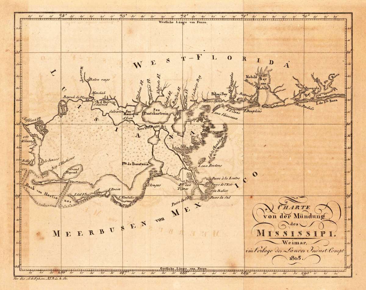
Charte von der Mündung des Mississipi. Weimar, im Verlage des Landes Indust. Compt. 1805.
(Industrie Comptoire) – Charte von der Mündung des Mississipi. Weimar, im Verla... · Antique Map, Copper Engraving · 168 x 215mm · Industrie Comptoire, Weima...
Eigenschaften
- Published: Industrie Comptoire , Weimar
- Published date: 1805
- Type: Antique Map, map
- Technique: Copper engraving / Uncolored
- Issue date: 1805
- Category: Western Florida & louisiana
- Size: 168 by 215mm (6 by 8 inches).
- Stock number: 19714
- Condition: In excellent condition. The map was originally published folded, so that the old fold is still slightly visible. Paper minor toned. 168 by 215mm (6 by 8 inches).
Article description
Article description
Copper Engraving, uncolored by (Industrie Comptoire), published 1805 by Industrie Comptoire, Weimar. Image size: 168 by 215mm (6 by 8 inches). The Industrie Comptoir was a Weimar-based German geographical publishing house active in the early 19th century, known for producing engraved maps and geographical works for the German scholarly market. Their map of the Mississippi Delta (1805) reflects the European geographical interest in the Louisiana Purchase region following Napoleon's sale of Louisiana to the United States in 1803. A very nice and quite detailed antique map, which shows the mouth of the Mississippi into the gulf of Mexico. With Pensacola in Western Florida, Mobile Bay in Alabama and Louisiana with New Orleans. The map is equipped with many place names, lakes, rivers, etc. An unusual early nineteenth century map published in Germany. In excellent condition. The map was originally published folded, so that the old fold is still slightly visible. Paper minor toned.(Industrie Comptoire) – Charte von der Mündung des Mississipi. Weimar, im Verla... · Antique Map, Copper Engraving · 168 x 215mm · Industrie Comptoire, Weima...
You might also be interested in the following products
 Johnson's Georgia...
 Lithograph, hand-colored in outline by Johnson & Browning, published 1859 by New York. Image size: 395 by 560mm...
€65.00
 Gray's New...
 Lithograph, original color in outline by Gray, Frank, published 1884 by O.W. Gray & Son, Philadelphia. Image...
€70.00
 Amér.Sep....
 Lithograph, hand-colored in outline by Vandermaelen, Phillippe Marie, published 1825 by Brussels. Image size: 463 by...
€177.00
 L'Ancien et...
 Copper Engraving, uncolored by Bonne, Rigobert, published 1787 by M. Bonne, Paris. Image size: 346 by 235mm (13 by 9...
€195.00
Recently viewed products