Blaeu, Guijelmus & Joan.
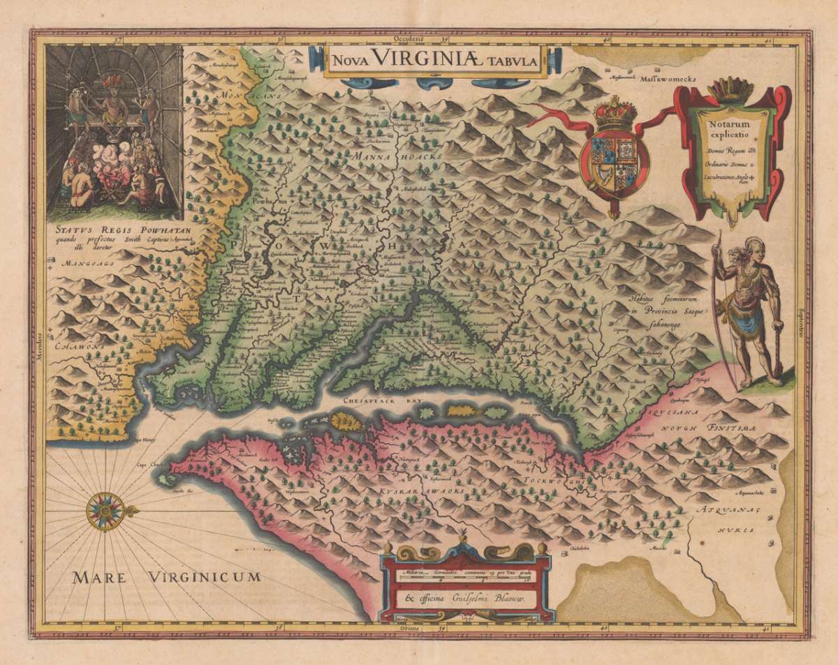
Nova Virginiae Tabula
€2,750.00
Prices incl. VAT plus shipping costs
This item is sold. Please contact us if you are searching for this item.
Eigenschaften
- Published: G. & J. Blaeu. , Amsterdam
- Published date: 1634
- Type: Antique Map, map
- Technique: Copper engraving / handcolored.
- Issue date: 1634-35
- Category: Virginia
- Size: 377 by 482mm (14 by 19 inches).
- Bibliography: Burden 193; Koeman Atlantes Neerlandici 9410:2.2; Tooley, The Mapping of America pp. 161/162 Derivative 1 State 2/2;
- Stock number: 19802
- Condition: In excellent condition. 377 by 482mm (14 by 19 inches).
Article description
Article description
Original antique copper engraving, hand colored in outline and wash when published in Joan Blaeu's 'Atlas Novus' German text edition in Amsterdam around 1634-35. Engraved by D. Grijp. This map was engraved after the famous map of Captain Smith's map of Virginia. This example is the 2nd state with the altered imprint 'ex officina Guiljelmi Blaeuw'. Blaeu used this map for the first time in his Atlantic Appendix (1630) and thereafter in virtually all editions of the atlas (Tooley). The appealing and quite detailed map is showing the discoveries of this region 'Virginia, the Chesapeake Bay and Maryland' after John Smith's map 1612. Blaeu's version of this map was the first map showing the Chesapeake region, that was really widely spread out by the Blaeu firm. It was one of the most detailed maps of the Chesapeake region, until 1673 in London the large four-sheet map by Augustine Herman was prepared. Joan Blaeu (23 September 1596 – 21 December 1673) was a Dutch cartographer born in Alkmaar, the son of cartographer Willem Blaeu. In 1620 he became a doctor of law but he joined the work of his father. In 1635 they published the Atlas Novus (full title: Theatrum orbis terrarum, sive, Atlas novus) in two volumes. Joan and his brother Cornelius took over the studio after their father died in 1638. Joan became the official cartographer of the Dutch East India Company. Blaeu's world map, Nova et Accuratissima Terrarum Orbis Tabula, incorporating the discoveries of Abel Tasman, was published in 1648. This map was revolutionary in that it "depicts the solar system according to the heliocentric theories of Nicolaus Copernicus, which show the earth revolving around the sun.... Although Copernicus's groundbreaking book On the Revolutions of the Spheres had been first printed in 1543, just over a century earlier, Blaeu was the first mapmaker to incorporate this revolutionary heliocentric theory into a map of the world." Blaeu's map was copied for the map of the world set into the pavement of the Groote Burger-Zaal of the new Amsterdam Town Hall, designed by the Dutch architect Jacob van Campen (now the Amsterdam Royal Palace), in 1655. Blaeu's Hollandia Nova was also depicted in his Archipelagus Orientalis sive Asiaticus published in 1659 in the Kurfürsten Atlas (Atlas of the Great Elector). and used by Melchisédech Thévenot to produce his map, Hollandia Nova—Terre Australe (1664). As Joan Blaeu, he also published the 12 volume "Le Grand Atlas, ou Cosmographie blaviane, en laquelle est exactement descritte la terre, la mer, et le ciel". One edition is dated 1663. That was folio (540 x 340 mm), and contained 593 engraved maps and plates. In March 2015, a copy was on sale for £750,000. Around 1649 Joan Blaeu published a collection of Dutch city maps named Toonneel der Steeden (Views of Cities). In 1651 he was voted into the Amsterdam council. In 1654 Joan published the first atlas of Scotland, devised by Timothy Pont. In 1662 he reissued the Atlas Novus, also known as Atlas Maior, in 11 volumes, and one for oceans.[citation needed] A cosmology was planned as their next project, but a fire destroyed the studio completely in 1672. (Wikipedia)Burden 193; Koeman Atlantes Neerlandici 9410:2.2; Tooley, The Mapping of America pp. 161/162 Derivative 1 State 2/2;
You might also be interested in the following products
 Reddition De...
 Copper Engraving, uncolored by Godefroy, Francois, published 1783 by Francois Godefroy and Nicolas Ponce, Paris....
€275.00
Recently viewed products