Ortelius, Abraham
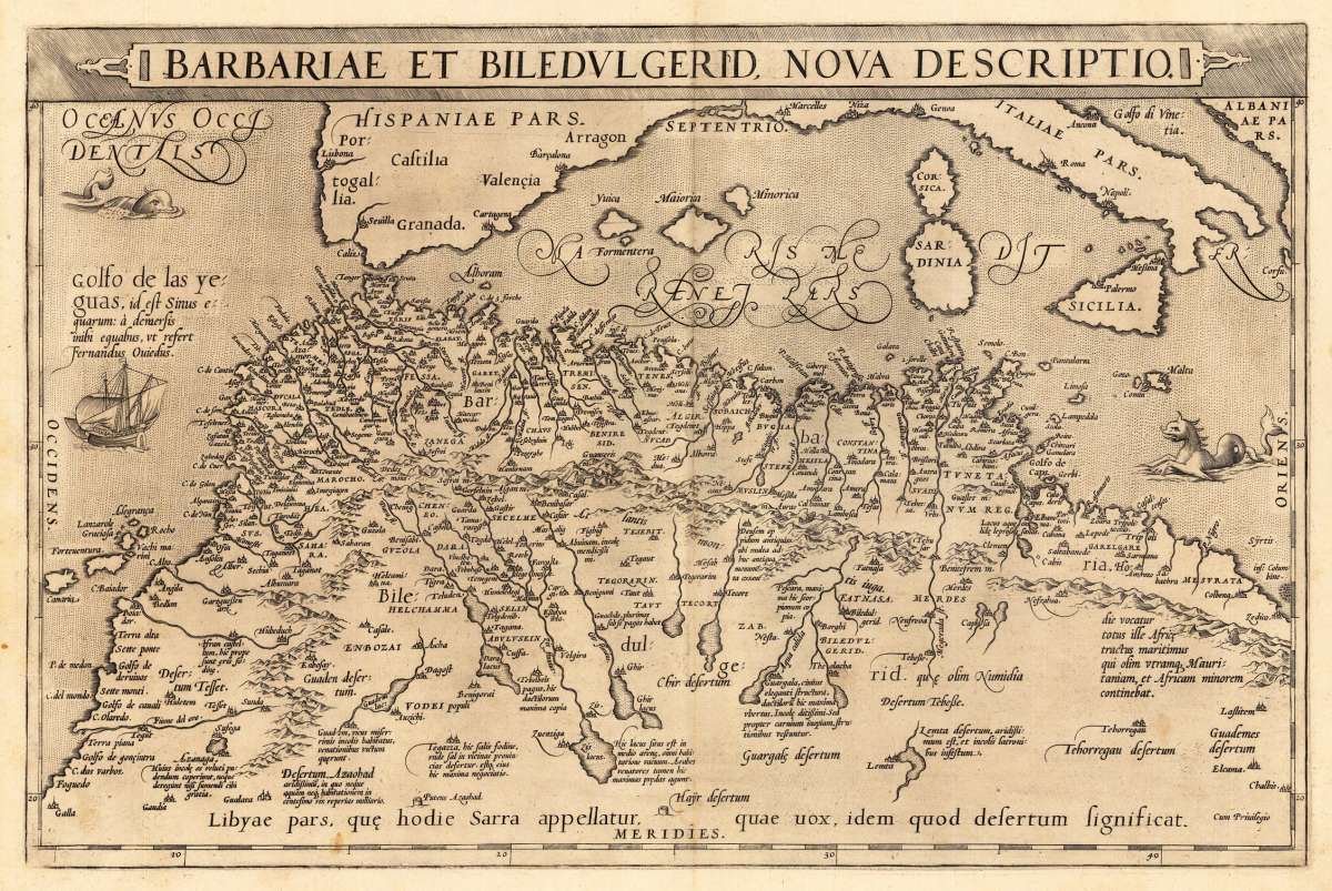
Barbariae et Biledulgerid, Nova Descriptio.
€395.00
Prices incl. VAT plus shipping costs
This item is sold. Please contact us if you are searching for this item.
Eigenschaften
- Published: Diesth , Antwerp
- Published date: 1573
- Type: Antique Map, map
- Technique: Copper engraving / Uncolored
- Issue date: 1573
- Category: Mediterranean Sea & North Africa
- Size: 330 by 500mm (13 by 19 inches).
- Bibliography: Koeman Ort. 11; Broe. 176
- Stock number: 23537
- Condition: In excellent condition. 330 by 500mm (13 by 19 inches).
Article description
Article description
Original antique copper engraving, published 1573 in a German text edition of the 'Theatrum Orbis Terrarum' at C. Diesth in Antwerp. This antique map shows North Africa with the Mediterranean Sea and the Atlantic coast. The map is equipped with many place names, rivers, mountains, towns, a small part of Italy, Sicily, the islands Corsica, Sardinia, Menorca, Mallorca, etc. The map is ornated with a large title cartouche in the upper margin, as well we find for decoration a sea monsters and a ship in the sea. Villages and towns are shown as miniature views. Ortelius was born on 14 April 1527 in the city of Antwerp, which was then in the Habsburg Netherlands (modern-day Belgium). The Orthellius family were originally from Augsburg, a Free imperial city of the Holy Roman Empire. In 1535, the family had fallen under suspicion of Protestantism. Following the death of Ortelius's father, his uncle Jacobus van Meteren returned from religious exile in England to take care of Ortelius. Abraham remained close to his cousin Emanuel van Meteren, who would later move to London. In 1575 he was appointed geographer to the king of Spain, Philip II, on the recommendation of Arias Montanus, who vouched for his orthodoxy. He travelled extensively in Europe and is specifically known to have traveled throughout the Seventeen Provinces; in southern, western, northern, and eastern Germany (e.g., 1560, 1575–1576); France (1559–1560); England and Ireland (1576); and Italy (1578, and perhaps twice or thrice between 1550 and 1558). Beginning as a map-engraver, in 1547 he entered the Antwerp Guild of Saint Luke as an illuminator of maps. He supplemented his income trading in books, prints, and maps, and his journeys included yearly visits to the Frankfurt book and print fair, where he met Gerardus Mercator in 1554. In 1560, however, when travelling with Mercator to Trier, Lorraine, and Poitiers, he seems to have been attracted, largely by Mercator's influence, towards the career of a scientific geographer. (Wikipedia)Koeman Ort. 11; Broe. 176
You might also be interested in the following products
 Aegypti Tabula
 Original copper engraving, uncolored. Published in Pierre Du Val's atlas ,Anderer Theil der allgemeinen...
€90.00
 Etats du Roi de...
 Original antique copper engraving, uncolored as published. Two interesting maps of North Africa on 1 double page...
€80.00
 Neueste Karte von...
 Steel engraving, in original colors, as published. A detailed map of Tunisia with many place names inland and along...
€80.00
 Neueste Karte von...
 Steel engraving, in original colors, as published. A detailed map of Nubia and Habesch with the Red Sea.
€60.00
Recently viewed products