Seutter, Matthäus
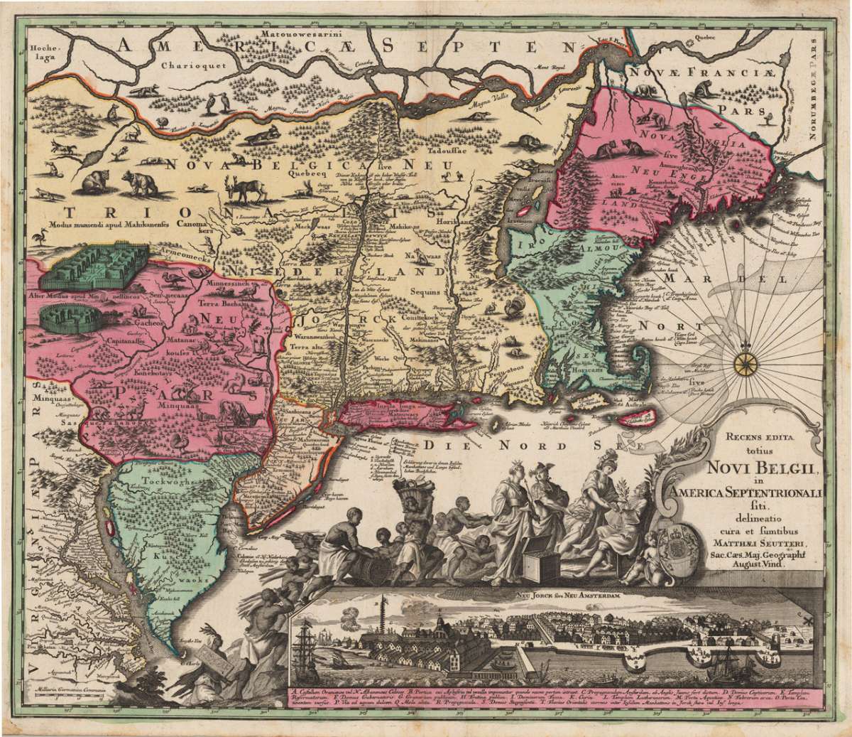
Recens edita totius Novi Belgii, in America Septentrionali siti, delineatio cura et sumtibus Matthaei Seutteri, Sac....
€3,400.00
Prices incl. VAT plus shipping costs
This item is sold. Please contact us if you are searching for this item.
Eigenschaften
- Published: Matthaeus Seutter , Augsburg
- Published date: 1730
- Technique: Copper engraving / Original color.
- Type: Antique Map, map
- Issue date: 1730
- Category: New York
- Size: 504 by 587mm (19 by 23 inches).
- Bibliography: Tooley, The Jansson-Visscher Maps of New England p.291 #25;
- Stock number: 24048
- Condition: A minor, hardly visible crease near the centre fold, else in excellent condition. 504 by 587mm (19 by 23 inches).
Article description
Article description
Copper engraving, hand colored in outline and wash when published. 2nd state of Matthaeus Seutter's map of the East coast from Virginia up to Massachusetts and Main. Seutter's map of New York is based on Jansson's and Justus Dancker's map of New England. In Seutter's map the 'Restitio cartouche' has been replaced by a new one showing Indians and gods presenting tribute to an English nobleman. This is probably George II. The map includes the distinctive course of the Delaware River, showing it separate from the Hudson River. Below the title cartouche we do find now a panoramic city view of New York 'Neu Jorck sive Neu Amsterdam', with a detailed table of explanations in Latin names below. Some place names and notes on the map have been translated from Dutch in Latin and German names. This is also the first map to show by means of printed lines the boundaries of Massachusetts, New England, New York, New Jersey and Pennsylvania.Tooley, The Jansson-Visscher Maps of New England p.291 #25;
You might also be interested in the following products
 Moluccae Insulae...
 Original antique copper engraving, hand colored in outline and wash when published. A highly decorative map of the...
€550.00
 Pascaert van...
 Original antique copper engraving, uncolored as published. Detailed chart of the Northeastern part of Canada,...
€1,750.00
 Pascaarte vande...
 Copper Engraving, uncolored by van Keulen, Joan, published 1684-1704 by Johannes van Keulen, Amsterdam. Image size:...
€1,100.00
 Guiana sive...
 Copper engraving, hand colored in outline and wash when published. French text edition. Decorative map extending...
€325.00
Recently viewed products