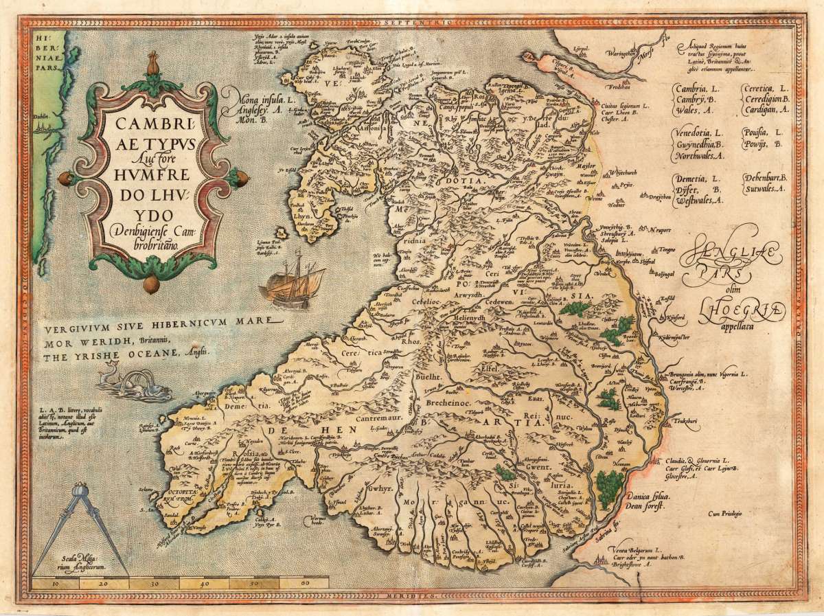
Ortelius, Abraham
Cambriae Typus Auctore Humfredo Lhvydo Denbigiense Cambrobritano.
€450.00
Prices incl. VAT plus shipping costs
This item is sold. Please contact us if you are searching for this item.
Eigenschaften
- Published: Platin , Antwerp
- Published date: 1579
- Type: Antique Map, map
- Technique: Copperengraving/handcolored., Copper engraving / hand colored.
- Category: Wales
- Issue date: 1579
- Size: 374 by 500mm (14 by 19 inches).
- Bibliography: Broe. 21 (state 1 of 2). Latin text edition.
- Stock number: 24051
- Condition: In excellent condition. 374 by 500mm (14 by 19 inches).
Article description
Article description
Original antique copper engraving, hand colored, published 1579 in a Latin text edition of the Atlas "Theatrum Orbis Terrarum" at Christopher Platin in Antwerp. A highly decorative map of Wales by the famous cartographer and mapmaker Abraham Ortelius based on the manuscript map by Lhuyds of 1568. The early map here in a strong impression, ornated with a ship and a sea monster. As well a beautiful renaissance text cartouche and a mileage scale with an navigation circle at the bottom. Ortelius was born on 14 April 1527 in the city of Antwerp, which was then in the Habsburg Netherlands (modern-day Belgium). The Orthellius family were originally from Augsburg, a Free imperial city of the Holy Roman Empire. In 1535, the family had fallen under suspicion of Protestantism. Following the death of Ortelius's father, his uncle Jacobus van Meteren returned from religious exile in England to take care of Ortelius. Abraham remained close to his cousin Emanuel van Meteren, who would later move to London. In 1575 he was appointed geographer to the king of Spain, Philip II, on the recommendation of Arias Montanus, who vouched for his orthodoxy. He travelled extensively in Europe and is specifically known to have traveled throughout the Seventeen Provinces; in southern, western, northern, and eastern Germany (e.g., 1560, 1575–1576); France (1559–1560); England and Ireland (1576); and Italy (1578, and perhaps twice or thrice between 1550 and 1558). Beginning as a map-engraver, in 1547 he entered the Antwerp Guild of Saint Luke as an illuminator of maps. He supplemented his income trading in books, prints, and maps, and his journeys included yearly visits to the Frankfurt book and print fair, where he met Gerardus Mercator in 1554. In 1560, however, when travelling with Mercator to Trier, Lorraine, and Poitiers, he seems to have been attracted, largely by Mercator's influence, towards the career of a scientific geographer. (Wikipedia)Broe. 21 (state 1 of 2). Latin text edition.
You might also be interested in the following products

 De Custen van...
 Fascinating detailed seachart of the south-eastern coast of England showing the coastline from Lizard Point over...
€950.00
 Neueste Karte von...
 Steelengraving, handcolored in outline when published. The detailled map of the British Isles is providing a lot of...
€80.00
 Anglia Cambdeni,...
 Original antique copper engraving, hand colored in outline and wash when published. Decorative detailled map...
€195.00
Recently viewed products